


- Veiði
- Sækja um veiðikort
- Næstu námskeið
- Sjúkdómar í villtum fuglum
- Veiðinámskeið
- Veiðikort
- Veiðitímabil
- Hvar má veiða?
- Náttúruverndarsvæði
- Þjóðlendur
 Hvar má veiða?
 - Spurt og svarað
- Veiðitölur
- Stjórnunar- og verndaráætlanir
- Hreindýr
- Fuglar
- Refir og minkar
- Refir
- Minkar
- Minkar lög og reglur
- Viðmiðunartaxtar
Refir og minkar - Veiðidagbækur
- Tekjur af sölu veiðikorta
- Rannsóknir og greinar
- Úthlutanir
- Starfsreglur
- Áætlanir
- Samráðsnefnd
Tekjur af sölu veiðikorta - Lög og reglur
Veiði - Loft
- Staða losunar á Íslandi
- Loftgæðamælir
- Loftgæði (uos.is)
- Losun gróðurhúsalofttegunda (uos.is)
- Losun loftmengunarefna (uos.is)
- Eldgos
- Flugeldar (uos.is)
- Viðskiptakerfi ESB - ETS (uos.is)
- Uppbygging kerfisins
- Iðnaður
- Flug
- CORSIA
- Skip
- Losunarheimildir
- Kolefnismarkaður
- Lög og reglur
Viðskiptakerfi ESB - ETS (uos.is) - Lög og reglur
- Loftslagsdagurinn (loftslagsdagurinn.is)
- Spurt og svarað
Loft - Haf og vatn
- Stjórn vatnamála
- Vatnavefsjá
- Strandhreinsun Íslands (uos.is)
- Bráðamengun
- Fráveitumál
- Leiðbeiningar
- Kröfur um hreinsun fráveituvatns
- Tveggja þrepa hreinsun
- Eins þreps hreinsun
- Ítarleg hreinsun
- Viðunandi hreinsun
- Minni fráveitur
- Eftirlitsmælingar
Kröfur um hreinsun fráveituvatns - Fræðsla
- Fráveita
- Fráveitan og umhverfið
- Staða fráveitumála
- Losun ferðasalerna
- Rekstur losunarstöðva
Losun ferðasalerna
Fráveitumál - Vöktun og ástand
- Vöktun í hafi
- Þorskur
- Kræklingur
- Nákuðungur
- Næringarefni í sjó
Vöktun í hafi - Vöktun á lofti og úrkomu
- Vöktun í straumvatni
Vöktun og ástand - Vöktun í hafi
- Alþjóðlegt samstarf
- Alþjóðlegir samningar
- Alþjóðlegar stofnanir
Alþjóðlegt samstarf - Plastmengun
- Lög og reglur
- Mengun frá skipum
- Varp í hafið og lagnir í sjó (uos.is)
- Varp í hafið
- Lagnir í sjó
Varp í hafið og lagnir í sjó (uos.is) - Móttaka úrgangs frá skipum
- Skyldur aðila
- Eftirlit
- Sóttvarnir
Móttaka úrgangs frá skipum - Almennt um vatn
- Álag á vatn
- Gott vatn fyrir alla
- Hringrás vatns
Almennt um vatn
Haf og vatn - Náttúra
- Finna friðlýst svæði
- Reglur í náttúru Íslands
- Friðlýsingar
- Ferill friðlýsinga
- Friðlýsingar í vinnslu
- Friðlýsingar í kynningu
- Friðlýsingar í bið
- Borgarvogur í Borgarbyggð
- Grótta
- Reykjatorfan - Reykjadalur/Grændalur
- Skerjafjörður við Álftanes
- Þjóðgarður á Vestfjörðum
- Kosning um nafn
- Tillaga að friðlýsingu
- Hvað er þjóðgarður?
- Þjóðgarður á sunnanverðum Vestfjörðum
- Hvað þarf til að svæði geti talist þjóðgarður?
- Friðlýsingarferlið
- Friðlýsingarskilmálar
- Stjórnun þjóðgarðs
- Áætlanir um framkvæmdir
- Miðstöðvar fyrir fræðslu og miðlun, þjóðgarðsvörð og landvörslu
- Samfélagsleg og hagræn áhrif þjóðgarðs
- Þjóðgarður og flutningskerfi raforku
- Þjóðgarður og samgöngumál
- Fundargerðir
- Upptaka frá opnum kynningarfundi
Þjóðgarður á Vestfjörðum - Skaftá - rammaáætlun
- Grafarvogur innan Gullinbrúar
Friðlýsingar í bið - Friðlýsingum lokið
- Friðlýst svæði
Friðlýsingar - Náttúruverndarsvæði
- Friðlýst svæði
- Vestfirðir
- Norðurland vestra
- Guðlaugs- og Álfgeirstungur
- Hrútey í Blöndu
- Stjórnunar- og verndaráætlun
Hrútey í Blöndu - Hveravellir á Kili
- Náttúra og jarðfræði
- Menning og saga
- Aðgengi og þjónusta
- Gönguleiðir
Hveravellir á Kili - Kattarauga, Áshreppi
- Miklavatn
- Spákonufellshöfði
- Stjórnunar og verndaráætlun
Spákonufellshöfði
Norðurland vestra - Norðurland eystra
- Böggvistaðafjall
- Dettifoss og fossaröð
- Dimmuborgir
- Fólkvangur í Glerárdal
- Friðland í Svarfaðardal
- Goðafoss í Þingeyjarsveit
- Stjórnunar- og verndaráætlun
Goðafoss í Þingeyjarsveit - Hellar á Þeistareykjum
- Hraun í Öxnadal
- Hverastrýtur í Eyjafirði
- Hverfjall
- Krossanesborgir
- Mývatn og Laxá
- Seljahjallagil
- Skútustaðagígar
- Vatnajökulsþjóðgarður
- Vestmannsvatn
Norðurland eystra - Vesturland
- Andakíll
- Bárðarlaug, Snæfellsbæ
- Blautós og Innstavogsnes
- Breiðafjörður
- Búðahraun
- Einkunnir, Borgarbyggð
- Eldborg í Hnappadal
- Friðland við Fitjaá í Skorradal
- Geitland, Borgarbyggð
- Grábrókargígar, Borgarbyggð
- Grunnafjörður
- Hraunfossar, Borgarbyggð
- Húsafellsskógur, Borgarbyggð
- Kalmanshellir
- Melrakkaey
- Steðji (Staupasteinn)
- Ströndin við Stapa og Hellna
- Stjórnunar- og verndaráætlun 2021-2030
- Kort og gögn
- Samráð og fundargerðir
Ströndin við Stapa og Hellna - Vatnshornsskógur, Skorradal
- Þjóðgarðurinn Snæfellsjökull
Vesturland - Leit eftir staðarheiti
- Austurland
- Suðvesturland
- Akurey
- Álafoss, Mosfellsbæ
- Ástjörn, Hafnarfirði
- Ástjörn og Ásfjall, Hafnarfirði
- Bakkatjörn, Seltjarnarnesi
- Bessastaðanes
- Bláfjallafólkvangur
- Blikastaðakró - Leiruvogur
- Borgir, Kópavogi
- Bringur, Mosfellsdal
- Búrfell, Garðabæ
- Eldborg í Bláfjöllum
- Eldborg við Geitahlíð
- Eldey, Reykjanesbæ
- Fjaran við Kasthúsatjörn
- Fossvogsbakkar, Reykjavík
- Garðahraun, Garðabæ
- Gálgahraun, Garðabæ
- Grótta, Seltjarnarnesi
- Hamarinn, Hafnarfirði
- Háubakkar, Reykjavík
- Hleinar, Hafnarfirði
- Hlið, Álftanesi
- Hvaleyrarlón og Hvaleyrarhöfði
- Kaldárhraun og Gjárnar
- Kasthúsatjörn, Álftanesi
- Laugarás, Reykjavík
- Litluborgir, Hafnarfirði
- Lundey í Kollafirði
- Rauðhólar, Reykjavík
- Reykjanesfólkvangur
- Skerjafjörður, Garðabæ
- Skerjafjörður, Kópavogi
- Stekkjarhraun, Hafnarfirði
- Tröllabörn, Lækjarbotnum
- Tungufoss, Mosfellsbæ
- Urriðakotshraun
- Valhúsahæð, Seltjarnarnesi
- Varmárósar, Mosfellsbæ
- Vífilsstaðavatn, Garðabæ
- Víghólar, Kópavogi
Suðvesturland - Suðurland
- Álftaversgígar
- Árnahellir í Leitahrauni
- Díma í Lóni
- Dverghamrar
- Dyrhólaey
- Um friðlandið
- Menning og saga
- Rannsóknir og fræðsla
- Umsjón og aðgengi
- Stjórnunar- og verndaráætlun 2021-2030
- Samráð og fundargerðir
Stjórnunar- og verndaráætlun 2021-2030
Dyrhólaey - Fjaðrárgljúfur
- Friðland að Fjallabaki
- Stjórnunar- og verndaráætlun
- Samráðsferlið og fundargerðir
- Ýmis gögn um friðlandið
- Kort og hnit
Stjórnunar- og verndaráætlun - Aðgengi og þjónusta
- Landmannalaugar
- Bóka bílastæði
- Spurt og svarað
- Um svæðið
Landmannalaugar - Útivist og gönguleiðir
- Náttúra og jarðfræði
- Menning og saga
- Ráðgjafanefnd friðlandsins
Friðland að Fjallabaki - Stjórnunar- og verndaráætlun
- Geysissvæðið
- Gullfoss
- Háalda
- Myndun jökulkers
Háalda - Herdísarvík
- Ingólfshöfði
- Jörundur í Lambahrauni
- Kerlingarfjöll
- Kirkjugólf
- Landslagsverndarsvæði Þjórsárdal
- Fræðsludagskrá 2022
- Samstarfsnefnd
- Stjórnunar- og verndaráætluna
- Vinnukort Göngu- hjóla- og reiðleiðir
Stjórnunar- og verndaráætluna
Landslagsverndarsvæði Þjórsárdal - Lónsöræfi
- Oddaflóð
- Ósland
- Pollengi og Tunguey
- Salthöfði og Salthöfðamýrar
- Skógafoss
- Surtsey
- Vatnajökulsþjóðgarður
- Viðey í Þjórsá
- Þjóðgarðurinn Þingvellir
- Þjórsárver
Suðurland
Friðlýst svæði - Snæfellsjökulsþjóðgarður
- Svæði með sterka innviði
- Náttúruminjaskrá
- Friðlýstar tegundir og náttúrufyrirbæri
- Dropsteinar
- Kúluskítur
- Plöntur
Friðlýstar tegundir og náttúrufyrirbæri - Ramsarsvæði
- Ástand náttúruverndarsvæða
- Ástandsmat áfangastaða innan friðlýstra svæða
- Áfangastaðir í hættu
- Grænir áfangastaðir
Ástandsmat áfangastaða innan friðlýstra svæða - Ástandsskýrsla friðlýstra svæða
Ástand náttúruverndarsvæða - Ástandsmat áfangastaða innan friðlýstra svæða
- Mývatn og Laxá
Náttúruverndarsvæði - Friðlýst svæði
- Kortasjá
- Landvarsla
- Hvað gera landverðir?
- Landvarðanámskeið
Landvarsla - Sjálfboðaliðar
- Umgengni um náttúru Íslands
- Stjórnunar- og verndaráætlanir
- Stjórnunar- og verndaráætlanir náttúruverndarsvæða
- Andakíll
- Akurey
- Álafoss, Mosfellsbæ
- Álafoss, viðauki
- Bárðarlaug
- Dimmuborgir
- Dverghamrar
- Dynjandi
- Dyrhólaey
- Fjaðrárgljúfur
- Flatey
- Fossvogsbakkar
- Friðland að Fjallabaki
- Friðland Svarfdæla
- Geysissvæðið
- Glerárdalur
- Goðafoss í Þingeyjarsveit
- Gullfoss
- Háubakkar
- Helgustaðanáma
- Hornstrandir
- Hólmanes
- Hrútey í Blöndu
- Hverfjall (Hverfell)
- Ingólfshöfði
- Jörundur
- Kaldárhraun og Gjárnar
- Kattarauga
- Kirkjugólf
- Kringilsárrani
- Laugarás
- Landslagsverndarsvæði Þjórsárdal
- Litluborgir
- Mývatn og Laxá
- Ósland
- Skógafoss
- Snæfellsjökulsþjóðgarður
- Spákonufellshöfði
- Steðji
- Strýturnar í Eyjafirði
- Ströndin við Stapa og Hellna
- Surtarbrandsgil
- Surtsey
- Tungufoss
- Varmárósar
Stjórnunar- og verndaráætlanir náttúruverndarsvæða - Stjórnunar- og verndaráætlanir villtra dýra og fugla
- Stjórnunar- og verndaráætlanir í kynningarferli
- Stjórnunar- og verndaráætlanir í vinnslu
- Dynjandi
- Fossvogsbakkar, Háubakkar og Laugarás
- Kerlingarfjöll
- Surtsey
- Teigarhorn
- Vífilsstaðavatn
Stjórnunar- og verndaráætlanir í vinnslu - Stjórnunar- og verndaráætlanir í vinnslu sem bíða staðfestingar
- Landslagsverndarsvæði norðan Dyrfjalla og náttúruvættið Stórurð
- Spurt og svarað
Landslagsverndarsvæði norðan Dyrfjalla og náttúruvættið Stórurð
Stjórnunar- og verndaráætlanir í vinnslu sem bíða staðfestingar - Landslagsverndarsvæði norðan Dyrfjalla og náttúruvættið Stórurð
- Stjórnunar- og verndaráætlanir í vinnslu en bið
- Hamarinn
- Hverastrýturnar í Eyjafirði
- Mývatn og Laxá
- Rauðhólar
- Samráðsáætlun
- Verk- og tímaáætlun
Rauðhólar
Stjórnunar- og verndaráætlanir í vinnslu en bið - Staða stjórnunar- og verndaráætlana
Stjórnunar- og verndaráætlanir - Stjórnunar- og verndaráætlanir náttúruverndarsvæða
- Framkvæmdaáætlun náttúruminjaskrár
- Hvað er framkvæmdaáætlun náttúruminjaskrár?
- Almenningur (við Geysi)
- Goðdalur í Bjarnarfirði
- Hengladalir
- Húsey og Eyjasel á Úthéraði
- Höfðaflatir við Vörðufell
- Lauffellsmýrar
- Norður Melrakkaslétta
- Lambeyrarkvísl og Oddauppsprettur í Borgarfirði
- Reykjanes Þorlákshver við Brúará
- Tjörnes
Framkvæmdaáætlun náttúruminjaskrár - Spurt og svarað
- Sækja um leyfi
- Drónaflug á friðlýstum svæðum
Sækja um leyfi - Afgreiðsla á leyfum
- Friðlýst svæði
- Friðlýst svæði - leyfi 2022
- Friðlýst svæði - leyfi 2021
- Friðlýst svæði - leyfi 2020
- Friðlýst svæði - leyfi 2019
- Friðlýst svæði - leyfi 2018
- Friðlýst svæði - leyfi 2017
- Friðlýst svæði - leyfi 2016
- Friðlýst svæði - leyfi 2015
- Friðlýst svæði - leyfi 2014
- Friðlýst svæði - leyfi 2013
- Friðlýst svæði - leyfi 2012
Friðlýst svæði - Akstur utan vega
- Lífríkismál
Afgreiðsla á leyfum - Friðlýst svæði
- Upplýsingar fyrir sveitarfélög
- Framandi lífverur
- Takmarkanir í náttúru Íslands
- Alþjóðlegar skuldbindingar
- Handbækur
Náttúra - Atvinnulíf
- Efni
- Hvað þarf ég að gera?
- Góð ráð um efnavörur
- Algengar spurningar
- Eftirlit, eftirfylgni og þvingunarúrræði
- Eldsneyti
- Flokkun og merking (CLP)
- Flúoraðar gróðurhúsalofttegundir
- Málning, lökk, kvikasilfur, RoHS
- Notendaleyfi fyrir plöntuverndarvörum
- Notendaleyfi fyrir útrýmingarefnum
- Ósoneyðandi efni
- Plöntuverndarvörur
- REACH
- Snyrtivörur
- Sæfivörur
- Þrávirk lífræn efni
- Þvotta- og hreinsiefni
- Öryggisblöð
Algengar spurningar - Efnavörur í Safety Gate tilkynningakerfinu
- Efnaeftirlit
- Niðurstöður efnaeftirlits
- Tímabundin stöðvun markaðssetningar
- Boðun eftirlits
- Samnorrænt eftirlitsverkefni með PFAS efnum í textíl í umhverfi barna
- Samevrópskt eftirlitsverkefni með tilteknum innihaldsefnum í snyrtivörum
- Eftirlit með plöntuverndarvörum á markaði 2024
- Eftirlit með sólarvörnum
- Eftirlit með upplýsingum um tilvist kerfis til endurheimtar bensíngufu á bensínstöðvum
- Eftirlit með hættulegum vörum til þrifa og viðhalds á bifreiðum
- Merkingar og umbúðir á uppkveikivökvum fyrir grill
- Markaðseftirlit með merkingum á skoteldum
- Eftirlit með stíflueyðum - merkingar og umbúðir
- Flokkun, merkingar, umbúðir, öryggisblöð og skráning á hættulegum efnablöndum framleiddum á Íslandi
Boðun eftirlits - Eftirlitsverkefni
- Eftirlitsverkefni 2024
- Eftirlitsverkefni 2023
- Eftirlitsverkefni 2022
- Úttekt á tollafgreiðslu plöntuverndarvara 2021
Eftirlitsverkefni 2022 - Eftirlitsverkefni 2021
- Efnagreiningar á ryki innandyra
- Eftirlit með innflutningi kælimiðla sem innihalda HFC fyrir árið 2020
- Úttekt á tollafgreiðslu plöntuverndarvara 2020
- Söluskrár 2020 fyrir plöntuverndarvörur og útrýmingarefni
- Eftirlit með plöntuverndarvörum á markaði 2021
- Sólarvarnir
- Norrænt eftirlitsverkefni um vörur sem innihalda tiltekin PFAS efni
- Markaðseftirlit með sæfivörum með áherslu á flokkun og merkingu
- Eftirlit með efnainnihaldi og merkingum handsótthreinsa
Eftirlitsverkefni 2021 - Eftirlitsverkefni 2020
- Takmarkanir skv. REACH - efnagreiningar
- Hættulegar vörur til þrifa og viðhalds á bifreiðum
- Sæfivörur á markaði í vöruflokki 19 með áherslu á fæliefni gegn skordýrum
- Plöntuverndarvörur á markaði 2020
- Söluskrár 2019 fyrir plöntuverndarvörur og útrýmingarefni
- Úttekt á tollafgreiðslu plöntuverndarvara 2019
- Tannhvítunarvörur til sölu í vefverslunum
Eftirlitsverkefni 2020 - Eftirlitsverkefni 2019
- Skráningar efna skv. REACH í kjölfar síðasta skráningarfrests
- Flokkun, merking og pökkun á hættulegum efnablöndum hjá innlendum framleiðendum
- Eftirlit með merkingum og umbúðum uppkveikivökva fyrir grill
- Plöntuverndarvörur á markaði 2019
- Úttekt á tollafgreiðslu plöntuverndarvara 2018
- Söluskrár 2018 fyrir plöntuverndarvörur og útrýmingarefni til notkunar í atvinnuskyni
- Efnagreiningar á ryki innandyra
Eftirlitsverkefni 2019 - Eftirlitsverkefni 2018
- Norrænt eftirlitsverkefni um efni í hlutum sem gefnir eru almenningi í kynningarskyni
- Eftirlit með merkingum og umbúðum stíflueyða
- Markaðseftirlit með merkingum á skoteldum
- Mánaðarlegt eftirlit með efnavörum á markaði með áherslu á merkingar
- Markaðseftirlit með sæfivörum með áherslu á flokkun og merkingu
- Plöntuverndarvörur á markaði 2018
- Úttekt á tollafgreiðslu plöntuverndarvara 2017
- Söluskrár 2017 fyrir plöntuverndarvörur og útrýmingarefni til notkunar í atvinnuskyni
- Eftirlit með snyrtivörum sem upprunnar eru í löndum utan EES
Eftirlitsverkefni 2018 - Eftirlitsverkefni 2017
- Skráningar í snyrtivöruvefgátt ESB (CPNP)
- Norrænt eftirlitsverkefni um flokkun og merkingar efnavara á byggingavörumarkaði
- Eftirlit með merkingum á hættulegum efnavörum í matvöruverslunum
- Merkingar og innihaldsefni í augnabrúna- og augnháralita
- Söluskrár fyrir plöntuverndarvörur og útrýmingarefni
- Úttekt á tollafgreiðslu plöntuverndarvara
- Plöntuverndarvörur á markaði 2017
Eftirlitsverkefni 2017 - Eftirlitsverkefni 2016
- Efnainnihald gúmmíkurls á gervigrasvöllum
- Eru ósoneyðandi kælimiðlar ennþá á markaði?
- Greining á söluskrám 2015 fyrir tiltekin varnarefni
- Snyrtivörur í torgsölu
- Innflutningur á einnota hylkjum með kælimiðlum
- Innflutningur kælimiðla - kallað eftir gögnum
- Merkingar á vörum til viðhalds á bílum
- Paraben í snyrtivörum frá löndum utan EES-svæðisins
- Plöntuverndarvörur á markaði 2016
- Úttekt á tollafgreiðslu á plöntuverndarvörum 2015
Eftirlitsverkefni 2016 - Eftirlitsverkefni 2015
- Úttekt á tollafgreiðslu plöntuverndarvara árið 2014
- Sólarvarnir á markaði - merkingar umbúða og innihaldsefni
- Snyrtivörur: : Merkingar og innihald andlitslita - Öskudagur
- Markaðsleyfi, merkingar og öryggisblöð sæfivara í gæludýraverslunum (PT19)
- Markaðsleyfi, merkingar og öryggisblöð nagdýra- og skordýraeiturs (PT14 og 18)
- Merkingar á umbúðum efnavara í matvöruverslunum
- Eftirlit með plöntuverndarvörum á markaði 2015
- Markaðsleyfi, merkingar og öryggisblöð fyrir viðarvarnarefni (PT8)
- Snyrtivörur: Merkingar og innihald andlitslita - Hrekkjarvaka
- Söluskrár 2014 fyrir plöntuverndarvörur og útrýmingarefni
- REACH-skráning, öryggisblöð og merkingar efna og efnablandna
- Eftirlit með merkingum eiturefna og annarra hættulegra efna 2015
- Eftirlit með hættulegum efnum í málningar- og byggingavöruverslunum 2015
- Eftirlit með merkingum tauþvottaefna seld almenningi
Eftirlitsverkefni 2015 - Eftirlitsverkefni 2014
- Eftirlit með nagdýra- og skordýraeitri
- Eftirlit með viðarvarnarefnum
- Hárlitir á markaði, merkingar og innihaldsefni
- Eftirlit með plöntuverndarvörum á markaði
- Úttekt á tollafgreiðslu plöntuverndarvara árið 2012 og 2013
- Merking umbúða og öryggisblöð efna og efnablandna í byggingarvöruverslunum
- Eftirlit með skráningu íslenskra snyrtivöruframleiðenda í Evrópugrunn (vefgátt CPNP) árið 2014
Eftirlitsverkefni 2014 - Eftirlitsverkefni 2013
- Eftirlitsverkefni 2025
Eftirlitsverkefni - Ábendingar og tilkynningar um ólöglega vöru
- Framkvæmd og heimildir
- Ársskýrslur teymis efnamála
- Eftirlitsáætlun
- Leiðbeiningar um efnaeftirlit
Efnaeftirlit - Eldsneyti
- Brennisteinsinnihald í tilteknu fljótandi eldsneyti
- Eftirlit með brennisteinsinnihaldi skipaolíu
- Samsett reglugerð nr. 124/2015
Brennisteinsinnihald í tilteknu fljótandi eldsneyti - Gæði eldsneytis
- Samsett reglugerð nr. 960/2016
Gæði eldsneytis - Skýrslugjöf til ESA
- Birgjar á skipaeldsneyti
Eldsneyti - Brennisteinsinnihald í tilteknu fljótandi eldsneyti
- Flokkun, merking og umbúðir
- Flokkun
- Merkingar og umbúðir
- Almennt um merkingar
- Hættumerki
- Merkingar samkvæmt CLP
- Hættu- og varnaðarsetningar
Merkingar og umbúðir - Efnaskrár
- Útgefið efni
- UFI-kóðar fyrir efnablöndur
Flokkun, merking og umbúðir - Flúoraðar gróðurhúsalofttegundir
- Notendaleyfi og ábyrgðarmenn
- Notendaleyfi fyrir plöntuverndarvörum
- Listi - Notendaleyfi í gildi
Notendaleyfi fyrir plöntuverndarvörum - Notendaleyfi fyrir útrýmingarefnum
- Ábyrgðarmenn í markaðssetningu
- Vegvísir fyrir leyfisskylda notkun
- Reglugerð um meðferð plöntuverndarvara og útrýmingarefna
Notendaleyfi og ábyrgðarmenn - Notendaleyfi fyrir plöntuverndarvörum
- Ósóneyðandi efni
- Plöntuverndarvörur
- REACH
- Snyrtivörur
- Sæfivörur
- Þrávirk lífræn efni
- Þvotta- og hreinsiefni
- Almennt um þvotta- og hreinsiefni
- Merkingar
- Innihaldsefni
- Reglugerð nr. 300/2014
Þvotta- og hreinsiefni - Öryggisblöð
- Nýjar kröfur varðandi öryggisblöð
Öryggisblöð - Efni í hlutum
- Hlutverk Umhverfisstofnunar
Efni - Eftirlit
- ETS
- Heilbrigðiseftirlit sveitarfélaga
- Heilbrigðiseftirlitssvæðin
- Leiðbeiningar og skýrslur
- Sóttvarnavottorð fyrir skip
- Starfsleyfisskilyrði
- Skráningaskyldur atvinnurekstur
- Starfsskilyrði
- Spurt og svarað
- Kynningarfundur
- Umsókn
Skráningaskyldur atvinnurekstur
Heilbrigðiseftirlit sveitarfélaga - Hollustuhættir
- Mengandi starfsemi
- Starfsleyfi
- Ál-, kísil- og kísiljárnver
- Efnaiðnaður
- Eldi sjávar- og ferskvatnslífvera
- Arctic Sea Farm, Arnarfirði
- Arctic Sea Farm, Dýrafirði
- Arctic Sea Farm, Ísafjarðardjúpi
- Arctic Sea Farm, Patreks- og Tálknafirði
- Arctic Sea Farm (Arctic Smolt), Tálknafirði
- Arnarlax, Arnarfirði
- Arnarlax, Gileyri
- Arnarlax ehf, í Fossfirði (Arnarfirði)
- Arnarlax ehf. Ísafjarðardjúpi
- Arnarlax, Patreks- og Tálknafirði
- Arnarlax, Þorlákshöfn (áður FISK-Seafood)
- Benchmark Genetics hf, Kalmanstjörn
- Benchmark Genetics hf, Kirkjuvogi
- Benchmark Genetics hf, Kollafirði
- Benchmark Genetics hf, Seljavogi
- Benchmark Genetics hf, Vogavík
- Bleikja ehf (áður Veiðifélag Eystri Rangár, Laugum)
- Eldisstöðin Ísþór, Þorlákshöfn
- Fagradalsbleikja, Vík
- First Water (áður Landeldi) Þorlákshöfn í Ölfusi
- First Water (áður Landeldi/Samherji) Öxnalæk Hveragerðisbæ
- Fiskeldi Austfjarða Bakka I - Ölfus (áður Laxar Fiskeldi)
- Fiskeldi Austfjarða., Berufirði
- Fiskeldi Austfjarða, Fáskrúðsfirði
- Fiskeldi Austfjarða, Fiskalóni-Ölfus (áður Laxar Fiskeldi.)
- Fiskeldi Austfjarða, Innra Lóni, Kelduhverfi (áður Rifós)
- Fiskeldi Austfjarða, Reyðarfirði (áður Laxar Fiskeldi)
- Fiskeldi Austfjarða, utanverðum Reyðarfirði (áður Laxar Fiskeldi)
- Fiskeldi Austfjarða, Röndinni. Kópasker (áður Rifós)
- Fiskeldi Austfjarða, Seyðisf. Háabakka
- Fiskeldi Austfjarða, Seyðisf. Sörlastaðavík
- Fiskeldi Austfjarða, Stöðvarfirði
- Fiskeldi Austfjarða, Þorlákshöfn (áður Laxar eignarhaldsfélag)
- Fiskeldið Haukamýri við Húsavík
- Fjallalax Grímsnesi
- Geo Salmo, Þorlákshöfn
- Hafrannsóknarstofnun, Stað, Grindavík
- Háafell, Ísafjarðardjúpi
- Háafell, Nauteyri
- Hábrún hf., Skutulsfirði
- Hið Norðlenzka Styrjufjelag ehf., Ólafsfirði
- Hið Norðlenzka Styrjufjelag ehf., Reykjanesi
- Hólaskóli - Háskólinn á Hólum, Hjaltadal
- Ís 47 ehf. - Önundarfirði
- Klausturbleikja, Skaftárhreppi
- Kristín Ósk Matthíasdóttir (áður Fiskabúrið), Seftjörn, Vatnsfirði
- Kynbótastöðin, Hólum í Hjaltadal
- Laugarseiði ehf., Eyjalandi (áður Veiðifélag Eystri Rangár)
- Laxey hf. Friðarhöfn (áður Icelandic Land Farmed Salmon ehf Vestmannaeyjum)
- Laxey hf. Viðlagafjöru, Vestmannaeyjum
- Laxós ehf. Árksógssandi
- Lindarfiskur ehf., Botnum
- Lækjarbotnableikja, Hellu
- Matís, Árleyni Reykjavík
- Matorka ehf., Hrauni, Grindavík
- Matorka ehf., Fellsmúla, Hellu
- Matorka ehf., Húsatóftum, Grindavík
- Nesvegur 5 ehf., Ásmundarnesi
- N-lax hf, Auðbrekka 9 Húsavík
- N-lax ehf, Laxamýri við Húsavík
- Samherji fiskeldi ehf. Stað Grindavík
- Samherji fiskeldi ehf. Kalmanshrauni, Reykjanesi
- Samherji fiskeldi ehf. Núpum III, Ölfusi
- Samherji fiskeldi ehf. Núpsmýri, Öxarfirði
- Samherji fiskeldi ehf. Sigtúnum, Öxarfirði
- Samherji fiskeldi ehf. Vatnsleysuströnd
- Stolt Sea Farm Reykjanesbær
- Sæbýli rekstur ehf Grindavík
- Thor landeldi ehf., Ölfusi
- Tungusilungur ehf., Tálknafirði
- Veiðifélag Kjósarhrepps Brynjudal
- Veiðifélag Landmannaafréttar, Galtalæk
- Veiðifélag Landmannaafréttar, Götu
- Veiðifélag Ytri-Rangár, Húsafell
- Víkurlax ehf., Ystu-Vík Eyjafjörður
- Ævintýradalurinn Heydalur
Eldi sjávar- og ferskvatnslífvera - Fiskimjölsverksmiðjur
- Föngun og geymsla koldíoxíðs
- Orka náttúrunnar ohf, hreinsivirki
- Carbfix hf., Nesjavöllum
- Carbfix hf., Hellisheiði
Föngun og geymsla koldíoxíðs - Lyfjaframleiðsla
- Malbikunarstöðvar
- Colas, Ammann 1, færanleg malbikunarstöð
- Colas, Ammann 2, færanleg malbikunarstöð
- Colas, Amomatic, færanleg malbikunarstöð
- Colas, Benninghoven, færanleg malbikunarstöð
- Colas, KVM, Hafnarfirði
- Colas, Marini, færanleg malbikunarstöð
- Malbikunarstöð Akureyrar, Akureyri
- Malbikstöðin, Esjumelum, Reykjavík
- Malbikunarstöðin Höfði, Hafnarfirði (áður Malbikunarstöðin Munck)
Malbikunarstöðvar - Olíubirgðarstöðvar
- Höfuðborgarsvæðið
- Vesturland
- Vestfirðir
- Norðurland
- Austurland
- Suðurland
- Suðurnes
- EBK Keflavíkurflugvelli
Suðurnes
Olíubirgðarstöðvar - Sláturhús
- Sláturfélag Suðurlands svf., Selfoss
Sláturhús - Úrgangur og efnamóttaka
- Höfuðborgarsvæðið
- Vesturland
- Vestfirðir
- Norðurland
- Austurland
- Suðurland
- Suðurnes
Úrgangur og efnamóttaka - Verksmiðjur
- Þauleldi
Starfsleyfi - Leiðbeiningar um starfsleyfi (uos.is)
- Sækja um starfsleyfi
- Erfðabreyttar lífverur
- Grænt bókhald
- Mengaður jarðvegur (uos.is)
- Tilkynna grun um mengun
- Kortasjá
- Umhverfisábyrgð
- Leiðbeiningar
Mengaður jarðvegur (uos.is) - Bráðabirgðaheimild
- Leiðbeiningar með umsókn (uos.is)
- Útgefnar bráðabirgðaheimildir
Bráðabirgðaheimild - Frágangur og vöktun urðunarstaða
- Akraneskaupstaður
- Akureyrarbær
- Árborg, Lækjarmót
- Blönduósbær
- Dalabyggð
- Fjarðabyggð, Heydalamelir
- Fjarðabyggð, Mjóafirði
- Grundarfjarðarbær
- Húnaþing vestra
- Ísafjarðarbær
- Langanesbyggð Þórshöfn
- Sorpstöð Suðurlands
- Sorpurðun Vesturlands
- Sveitarfélagið Hornafjörður
- Sveitarfélagið Skagafjörður
- Sveitarfélagið Skagaströnd
- Vestmannaeyjabær
- Vesturbyggð
Frágangur og vöktun urðunarstaða - Starfsleyfi úr gildi
- Advanced Marine Services Limited
- Alur álvinnsla, Helguvík
- Arctic Oddi, Önundafjörður
- Arctic Oddi, Skötufjörður
- Arctic Sea Farm, Dýrafirði, 200 tonn
- Arctic Sea Farm, Önundarfirði
- BA-337, Tálknafjörður
- Bleikjustöðin Viðvík, Sauðárkróki
- Efnaeiming ehf.
- Efnamóttakan, Gufunesi
- Efnarás, Reykjavík
- Einherji, Ósafirði
- Fjarðareldi, Skutulsfirði
- Glaður ehf., Bolungarvík
- Gunnvör hf., Ísafirði
- Gunnvör hf., Mjóafirði
- H. Kristjánsson, Mjóafirði (áður Tó Fiskeldi)
- Háafell, Ísafjörður
- Hraðfrystihúsið Gunnvör, Álfta- og Seyðisfirði
- Hraðfrystihúsið Gunnvör hf., Bæjarhlíð
- Hraðfrystihúsið Gunnvör hf., Skötufirði
- Hringrás hf. Akureyri
- Hringrás hf., Reyðarfirði
- Icelandic Glacier Charr ehf., Ytri-Tungu , Kirkjubæjarklaustri
- IS-47, Ísafirði
- Ísafjarðarbær
- Íslandsbleikja, Eyjafjörður
- Íslandslax, Eyjafirði
- Íslenska gámafélagið
- Íslenska gámafélagið, Hellislandi
- Íslenska Gámafélagið, Gufunesi
- Jöklableikja ehf., Suðursveit
- Krossanes ehf.
- Malbikunarstöðin Höfði, Reykjavík
- Matfugl, Ytra-Holt
- Matorka, Galtalæk, Hellu
- Nesbik ehf. Krossanesi
- Norðurál, Helguvík
- Olíudreifing ehf, Akranesi
- Olíudreifing ehf, Djúpavogi
- Olíudreifing ehf, Fáskrúðsfirði
- Olíudreifing, Flatey
- Olíudreifing, Húsavík
- Olíudreifing, Sauðárkróki
- Olíudreifing, Siglufirði
- Samherji, Grindavík
- Samherji fiskeldi ehf., Mjóafirði
- Sementsverksmiðjan, Akranesi
- Straumfiskur
- Sigurður Magnússon (Kjarnableikja), áður Bleikjueldi – Hofi II
- Silungur-eldisstöð ehf, Laxalóni
- Síldarvinnslan, Helguvík
- Seyra ehf.
- Sorpsamlag Þingeyinga
- Skeljungur, Bolungarvík
- Skeljungur, Grindavík
- Skeljungur, Húsavík
- Skeljungur, Raufarhöfn
- Skeljungur, Seyðisfirði
- Skeljungur, Patreksfirði
- Sjávareldi ehf., Skutulsfirði
- Skipasmíðastöð Njarðvíkur h.f.
- Sveinn Sigurjónsson - fiskeldi
- Sæbýli ehf., Eyrarbakka
- Thorsil, Helguvík
- Verið vísindagarðar, Hólum í Hjaltadal
- Þorskeldi, Berufirði
- Þorskeldi ehf, Fáskrúðsfirði
- Þorskeldi ehf. Stöðvafirði
- Öggur, Hjaltadal
Starfsleyfi úr gildi - Eftirlitsáætlanir
- Eftirlitsáætlun 2022
- Eftirlitsáætlun 2021
- Eftirlitsáætlun 2020
Eftirlitsáætlanir
Mengandi starfsemi - Starfsleyfi
- Opinber birting
- Sérstakt eftirlit
- Starfsleyfi
- Umsagnir
- Skipulagstillögur
- Skipulagstillögur 2022
- Skipulagstillögur 2021
- Skipulagstillögur 2020
- Skipulagstillögur 2019
- Skipulagstillögur 2018
- Skipulagstillögur 2017
- Skipulagstillögur 2016
- Skipulagstillögur 2015
- Skipulagstillögur 2014
- Skipulagstillögur 2013
- Skipulagstillögur 2012
- Skipulagstillögur 2011
- Skipulagstillögur 2010
- Skipulagstillögur 2009
- Skipulagstillögur 2008
- Skipulagstillögur 2007
- Skipulagstillögur 2006
- Skipulagstillögur 2005
- Skipulagstillögur 2004
- Skipulagstillögur 2003
- Skipulagstillögur 2003-2022
Skipulagstillögur - Mat á umhverfisáhrifum
- Mat á umhverfisáhrifum 2023
- Mat á umhverfisáhrifum 2022
- Mat á umhverfisáhrifum 2021
- Mat á umhverfisáhrifum 2020
- Mat á umhverfisáhrifum 2019
- Mat á umhverfisáhrifum 2018
- Mat á umhverfisáhrifum 2017
- Mat á umhverfisáhrifum 2016
- Mat á umhverfisáhrifum 2015
- Mat á umhverfisáhrifum 2014
- Mat á umhverfisáhrifum 2013
- Mat á umhverfisáhrifum 2012
- Mat á umhverfisáhrifum 2011
- Mat á umhverfisáhrifum 2010
- Mat á umhverfisáhrifum 2009
- Mat á umhverfisáhrifum 2008
- Mat á umhverfisáhrifum 2007
- Mat á umhverfisáhrifum 2006
- Mat á umhverfisáhrifum 2005
- Mat á umhverfisáhrifum 2004
- Mat á umhverfisáhrifum 2003
- Mat á umhverfisáhrifum 2003-2022
Mat á umhverfisáhrifum - Þingmál og samráðsgátt
- Aðrar umsagnir
Umsagnir - Skipulagstillögur
- Úrgangsmál
- Endurvinnsla skipa
- Flutningur úrgangs milli landa
- Flutningur endurvinnsluefna
- Flutningur hættulegs úrgangs
- Eftirlit með flutningi úrgangs
Flutningur úrgangs milli landa - Gagnagátt fyrir úrgangstölur
- Leiðbeiningar til rekstraraðila vegna gagnaskila (pdf)
Gagnagátt fyrir úrgangstölur - Meðhöndlun úrgangs í heimsfaraldri
- Úrgangur frá alþjóðlegum flutningstækjum
- Spurt og svarað
Úrgangur frá alþjóðlegum flutningstækjum - Raf- og rafeindatæki
- Rafhlöður og rafgeymar
- Úrgangur verður að vöru - Ráðgefandi álit
- Viðmið vegna hauggass
Úrgangsmál
Atvinnulíf - Efni
- Hringrásarhagkerfi
- Hringrásarhagkerfið
- Vottanir og merkingar
- Grænn lífstíll
- Börn
- Fatnaður
- Flokkun og endurvinnsla
- Garðurinn
- Hringrásarhagkerfið
- Innbú
- Jól og áramót
- Kolefnisjöfnun
- Matarsóun
- Matvæli
- Meðhöndlaðar vörur
- Neysluvenjur
- Plast
- Raftæki
- Samgöngur
- Vistvænar samgöngur
- Bílar
- Ferðalög
Samgöngur - Snyrtivörur
- Varasöm efni
- Vottanir og aðrar merkingar
- Áreiðanleg umhverfismerki
- Umhverfismerkið Svanurinn
- Blómið
- Viðmið Blómsins
Blómið - Blái engillinn
- Bra Miljöval
- Green Seal
Áreiðanleg umhverfismerki - Lífrænt
- Aðrar merkingar
- Orka
- Sjálfbært
- Sanngjarnt
- Heilnæmi
- Gæðastýring
Aðrar merkingar - Grænþvottur
- Hættumerki
Vottanir og aðrar merkingar - Áreiðanleg umhverfismerki
- Þvotta- og hreinsivörur
Grænn lífstíll - Græn skref
- Svanurinn
- Saman gegn sóun
- Matarsóun
- Hollustuhættir
- Úrgangsmál
- Umhverfisvísar og tölfræði
- Heildarmagn og meðhöndlun
- Tölfræði
- Bætt úrgangstölfræði
Umhverfisvísar og tölfræði - Losun ferðasalerna
Úrgangsmál - Umhverfisvísar og tölfræði
Hringrásarhagkerfi - Umhverfisstofnun
- Fyrir fjölmiðla
- Senda ábendingu
- Hlutverk og stefna
- Stefna Umhverfisstofnunar
- Náttúruvernd
- Heilnæmi
- Hringrásarhagkerfið
- Loftslagsmál
- Þjónusta
Stefna Umhverfisstofnunar - Hlutverk og verkefni
- Fjölskyldustefna
- Gæðastefna
- Jafnréttisáætlun
- Launa- og jafnlaunastefna
- Mannauðsstefna
- Persónuverndarstefna
- Samráðsstefna
- Stafræn stefna
- Umhverfis- og loftslagsstefna
- Upplýsingastefna
- Upplýsingatæknistefna
- Þjónustustefna
- Öryggis- og heilsustefna
Hlutverk og stefna - Stefna Umhverfisstofnunar
- Þjónusta
- Innra umhverfisstarf
- Umhverfis- og loftslagsstefna
- Loftslagsmarkmið
- Umhverfisskýrslur
Innra umhverfisstarf - Spurt og svarað
- Starfsfólk (uos.is)
- Fréttir
- Útgefið efni
- Ársáætlanir
- Ársskýrslur
- Ástand friðlýstra svæða
- Bæklingar
- Endurskoðunarskýrslur
- Friðlýsingar
- Opnir fyrirlestrar
- Umhverfisskýrslur
- Veiðidagbækur
- Annað útgefið efni
- Aðferðir við sýnatöku mengaðs jarðvegs
- Skráning úrgangsstaða
- Food Waste in Iceland 2022
- Hvað er nýtt? Kortlagning á endurnotkun á Íslandi 2023
- Kortlagning endurnotkunar og úrgangsforvarna
- Guidelines for cruise and passenger ships arriving in Iceland 2024
- Leiðbeiningar fyrir stjórnendur farþegaskipa sem koma til Íslands 2024
- Sund og baðstaðir - Handbók 2020
- Skýrsla friðlýstra svæða á Norðurlandi eystra 2017
- Skýrsla friðlýstra svæða á Norðurlandi eystra 2016
- Þrif og öryggisatriði í íþróttahúsum
- Integrated Monitoring at Litla-Skard, Iceland
- Umhverfisstjórnunarkerfi, Ársskýrsla 2010
- Eftirlitsverkefni með gæðum laugarvatns og öryggi á sundstöðum, sumarið 2008
- Landsáætlun um loftgæði
- Framkvæmdaáætlun um varnir gegn mengun sjávar frá landi
- Leiðbeiningar um olíuskiljur
- Úttekt á mengunarvörnum í bifreiðasprautuverkstæðum
- Öryggisatriði á dvalarheimilum aldraðra 2012
- Leikvallatæki, skoðunarhandbók
- Úttekt á mengunarvörnum í efnalaugum á Íslandi
- Strand Wilson Muuga, skýrsla
- Leiðbeiningar um meðferð olíumengaðs jarðvegs
- Strand m.s. Víkartinds, rannsókn
- Starfsreglur um góða búskaparhætti
- Vöktunaráætlun fiskeldisstöðva
- Olíuskiljuverkefni 2012
- Upplýsingar um veggjalús
- Friðlýsingar 2012
- Handbók um aðgerðaráætlanir og flokkun vatns
- Leiðbeiningar um rotþrær og siturlagnir
- Report to the EFTA Surveilance Authority regarding the implementation of Directive 91/271/EU on the treatment of wastewater from agglomerations
- Eftirlitsverkefni með gæðum baðvatns og öryggi á sund og baðstöðum 2013
- Mælingar á mengandi efnum á og við Ísland
- Friðlýsingar 2013
- Uppgjör 2008-2012
- Markmið og stefna 2013-2017
- Leiðbeiningar um móttöku úrgangs á urðunarstöðum
- Aðgerðaáætlun Umhverfisstofnunar, Landhelgisgæslu Íslands og Samgöngustofu um viðbrögð við bráðamengun utan hafna og notkun skipaafdrepa
- Eftirlitsverkefni 2015 - þrif í leik- og grunnskólum
- Eftirlitsverkefni 2016 - Hávaði í umhverfi barna í leik- og grunnskólum
- Samantekt um stöðu fráveitumála á Íslandi árið 2014
Annað útgefið efni
Útgefið efni - Fjölmiðlar og merki
- Merki
Fjölmiðlar og merki - Lög og reglur
- Senda ábendingu
Umhverfisstofnun
Vinna við nýjar heimasíður Umhverfis- og orkustofnunar og Náttúruverndarstofnunar er í gangi. Heimasíða Umhverfisstofnunar er virk á meðan vinnunni stendur. Information in English
Stök frétt
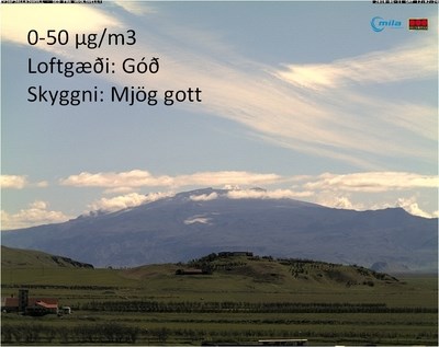
The Environment Agency of Iceland (EA) monitors air quality in Iceland. During a volcanic eruption in Eyjafjallajökull, South-Iceland, which lasted for a few weeks, volcanic ash spread over the surrounding area. On windy days this ash is resubmitted to the air and as a result, particulate matter (PM10) concentration levels have been unusually high in the neighbourhood of the volcano. The EA currently monitors the air quality at three locations, Vík in Mýrdalur, Raufarfell and Hvolsvöllur (see map) and the actual levels can be observed on the web-site.

Due to the fact that it is impossible to monitor PM10 levels everywhere and the frequently asked questions such as “How is it possible to estimate PM10 levels visually?” and “What other means, other than measurements, can be used to estimate PM10 levels?” the EA has composed a short video using photos from Hvolsvöllur taken at different PM10 concentrations. The aim of this video is to compare visibility at different PM10 concentrations and should only be used as a guideline to help evaluate PM10 concentrations. The given examples do not apply for every situation.
To estimate visibility it is convenient to use objects in different distances such as houses, hills, mountains, light poles etc. Object visibility can though vary due to different factors e.g. the colour of the object, texture, height, altitude and more and it is important to mention that the human eye sees differently than a camera lens.
Here you can see the video.
The photos were provided by Mila ehf. and compiled by the Environment Agency of Iceland.